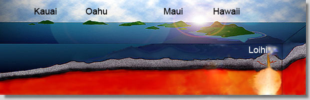
رخدادهاى زمينساختى پالئوزوييک
«نخستين حرکت زمينساختى پالئوزوييک (رخداد زريگانين )
«دومين حرکت زمينساختى پالئوزوييک (ميلايين - Milaian )
«چهارمين حرکت زمينساختى پالئوزوييک (هرسينين )
«نخستين حرکت زمينساختى پالئوزوييک (رخداد زريگانين )
«دومين حرکت زمينساختى پالئوزوييک (ميلايين - Milaian )
«چهارمين حرکت زمينساختى پالئوزوييک (هرسينين )
» رخداد ائوسن – اليگوسن پيرنئن Pyrenean))
» رخداد اليگوسن پسين – ميوسن پيشين ساوين (Savian )
» رخداد ميوسن ميانى استيرينStyrian) )
» رخداد ميوسن پسين – پليوسن آتيکانAtikan) )
» رخداد اواخر پليوسن )پاسادنين Pasadenian )
» فاز كوهزايي والانژين
» رخداد ترياس پسين (سيمرين پيشين)
» رخداد ژوراسيک ميانى (سيمرين ميانى)
» حــركـات كـوهـزايـي سـيـمـريـن پـسـيـن
» فاز كوهزايي لاراميد
The San Andreas Fault Zone is a major structural and physiographic feature in California. Many features of the movement can be seen either on a geologic map or out in the field.
Faults crop out as linear features along the Earth's surface and usually provide an easily eroded zone between harder, unfaulted rock. Thus they can localize narrow linear valleys such as the San Andreas "Rift" Zone, separating Pt. Reyes Peninsula to the west from mainland California to the east in the photo below.

by
Carlos Cramez & Jean Letouzey
Geologic Structures Diagrams
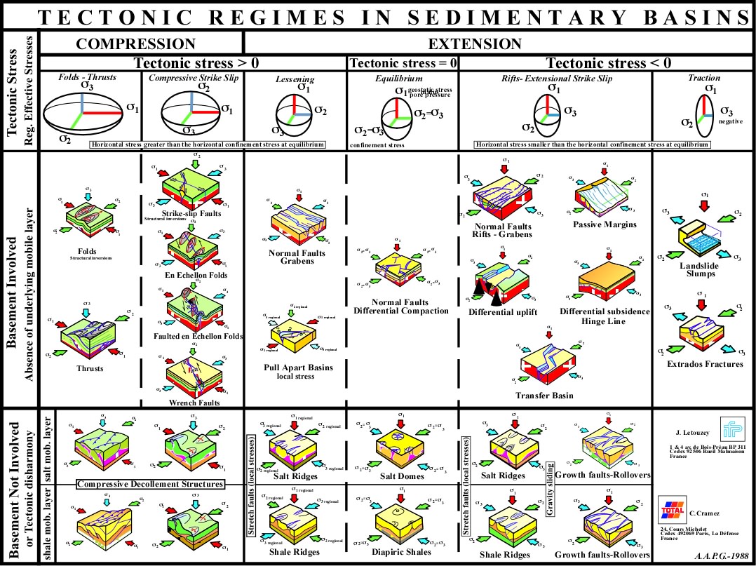
In a subduction zone the earthquake foci normally plot along a dipping plane at an angle of 33 to 60 degrees and this plane is called a Benioff zone. The zone is named after Hugo Benioff, a US seismologist who first described this feature. The Benioff zone extends to a depth of about 700 km.
The plates consist of an outer layer of the Earth, the lithosphere, which is cool enough to behave as a more or less rigid shell. Occasionally the hot asthenosphere of the Earth finds a weak place in the lithosphere to rise buoyantly as a plume, or hotspot. The satellite image below shows the volcanic islands of the Galapagos hotspot.
Folds....Faults
Anticlines and Synclines-Class Notes

Plate Tectonics Theory

برای دیدن عکس ها به ادامه مطلب مراجعه کنید
|
|
|
![]() |
|
Tectonic Map of the World picture from the Great Soviet Encyclopedia (GSE), 1970–1977 There were three GSE editions. The first edition of 65 volumes (65,000 entries, plus a supplementary volume about the Soviet Union) was published during 1926–1947. The second edition of 50 volumes (100,000 entries, plus a supplementary volume) was published in 1950–1958. The third edition of 1970–1977 contains 30 volumes (100,000 entries, plus an index volume issued in 1981. The GSE contents articles about the Soviet Union and all countries of the world |
● پهنه رسوبی – ساختاری البرز
پهنه رسوبی – ساختاری البرز شامل بلندیهای شمال صفحه ایران است که به شکل تاقدیسی مرکب(Anticlinorium) ، در یک راستای عمومی خاوری – باختری، از آذربایجان تا خراسان امتداد دارد.
